KONYA ALAEDDİN HILL
II. KILIÇARSLAN PALACE AND EXCAVATION AREA
ARCHITECTURAL DESIGN PROJECT COMPETITION
Team: Architect Gülay Didir - Architect Peker Ayan
Architect Sinan Çorak - Landscape Architect Bilge Kobak
Interior Designer Beste Güllü - Archaeologist İlkiz Öztürk
Civil Engineer Mehtap Demir - Art Historian Berk Kır
Architecture Student Zeynep Aslan
Two-Stage Architectural Design Competition Organized by Konya Municipality
Location: Konya, Turkey Status: Participant (eliminated in the final round) Periyod: March 2023
The provided text discusses the concept of parallax in the context of Alaeddin Hill. It explains that parallax refers to the angle formed when observing the same point from two different points, representing the change perceived by an observer when looking at the same point from two different locations. In the context of Alaeddin Hill, the discussion focuses on treating it as a parallax space, emphasizing the changing spatial forms it has undergone over time.
The proposed project for the competition aims to reinterpret Alaeddin Hill as a parallax space, expressing its different spatial forms throughout history through an abstract narrative. The design envisions reflecting the changes in spatial forms within the mound based on accessible information about the archaeological remnants. The goal is for the inhabitants of the city to experience the archaeological remains within the mound as a parallax space, providing a unique perspective on the changes over time.
The layered history of Konya, with traces from the Hittites, Phrygians, Lydians, Eastern Romans, Seljuks, and the Ottoman Empire, is noted. The proposal suggests developing ideas for preserving these traces, particularly within the mound's fortification walls. The comprehensive proposal plans to reveal the layers with a designed timeline and aims to transform Alaeddin Hill into an Urban Archaeological Site and Archaeopark.
The discussion touches on the significance of the mound as the acropolis of the city during the classical period and its continued importance as the focal point throughout history. Changes in defense strategies during the Seljuk period are mentioned, leading to a shift in the function of inner walls from defense to enclosing the palace. Over time, the palace and inner walls lost their importance, transforming into a quarry where stones could be extracted for other structures during the Ottoman period.
The text concludes by emphasizing the desire to establish a spatial and functional connection between the past and present through architectural design, aiming to reinterpret the archaeological area as a parallax space.
The Relationship Established with the City
The text discusses urban decisions made to strengthen the integration between Alaeddin Hill and the city of Konya.
Transportation Decision: To prioritize pedestrian focus in the city center and reduce potential damage to the archaeological area from vibrations caused by the tramway line, a new transportation proposal has been introduced. In this context, the west and south directions of Alaeddin Boulevard, apart from service functions, have been closed to vehicles. The last stops of two tramway lines have been terminated before reaching Alaeddin Hill. The western part of Alaeddin Boulevard has been pedestrianized to integrate the Zafer Square, located within the expanding hill boundary, into the area. To regain the trace of the lost city walls, it is proposed to expand the boundaries of the hill area. Within the expanded area, the demolition of low-quality structures and the restoration of the historical path alignment are planned.
Urban Decisions: The existing connection between the area and the Mevlana Museum has been identified, and a cultural route has been established to enhance the connection between these two areas and the historical structures in between. However, it has been observed that the connection with the Archaeology Museum and Ethnography Museum, two of the city's most important museums, is disconnected. As part of the expansion of the area boundaries, targeted interventions, including bike lanes, pop-up spaces, urban furniture, and directional elements with point interventions on streets connecting the museum and the area, have been planned. These interventions include the addition of bike lanes, pop-up spaces, urban furniture, and exhibition areas featuring wall drawings created by local artists.
Archaeopark Decision

In the current situation, Alaeddin Hill, which was previously designated as an "Archaeological, Historical, and Natural Site Area" by the decision of the Board of Real Estate Ancient Monuments and Memorials (GEEAYK) on November 13, 1982 (Decision No: A-3861), and later defined as a "Natural Site - Qualified Natural Conservation Area" by the approval of the Ministry of Environment and Urbanization on May 10, 2019 (Approval No: 110955), is now highlighted in the proposed project. The decision has been made to emphasize the archaeological significance of Alaeddin Hill by elevating its status to "Urban Archaeological Site and Archaeopark."
Mound Phasing Strategies
Completing all stages of the proposed project may require a process spanning over 100 years. It is recommended that the mound continues to function as a recreational area throughout all stages, and the final product design is developed based on the findings. This approach will allow the transformation process to unfold over time, creating a participatory and fluid process that can be observed by the urban community and seamlessly integrated into urban memory.
Conservation and Revitalization Strategies Within the Mound Boundaries
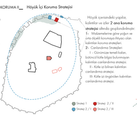
Strategies for the Conservation of Existing Excavation Sites
To ensure the continued preservation of archaeological artifacts and immovables within the first-degree archaeological site at Alaeddin Hill, systematic and scientific material analyses are necessary. Utilizing the information within the scope of the competition, an existing material analysis has been conducted, and the proposed plan has been developed based on these findings.
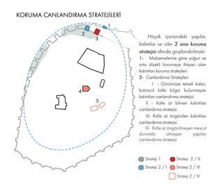
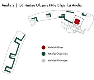
The structures located on Alaeddin Hill have undergone research from various sources within the scope of the competition. Information obtained regarding the form of these structures has been translated into Massing Information Trace Analysis. The conservation/revitalization strategy has been examined in three different groups based on this analysis:
I- Palace Wall and Entrance Gate
Revitalization strategy for remnants with preserved foundations, lacking comprehensive massing information.
II- Kılıçarslan Mansion
Revitalization strategy for remnants with known massing information.
III- Ruins
Protection strategy from external elements with no revitalization proposal.
Drifting Urban Traces

Throughout history, it is known that fragments of cities, which have remained in ruins, were used as quarries for the construction of new buildings. This circumstance has been applicable to Alaeddin Hill from the past to the present day. Especially emphasized by travelers, the dismantling of stones from the castle for the construction of Şeyh Ahmed Efendi Mosque, Bath, and Government Mansion is highlighted. Considering the transportation of stones from the palace and their reuse in different structures in the city, the proposed project aims to ensure the continuity of these stones. In this context, it is planned to use the soil extracted from excavations within the proposed Conservation/Revitalization strategy.
Protective Coverings and the Methodology for Developing Revitalization Strategies

Protective Covers
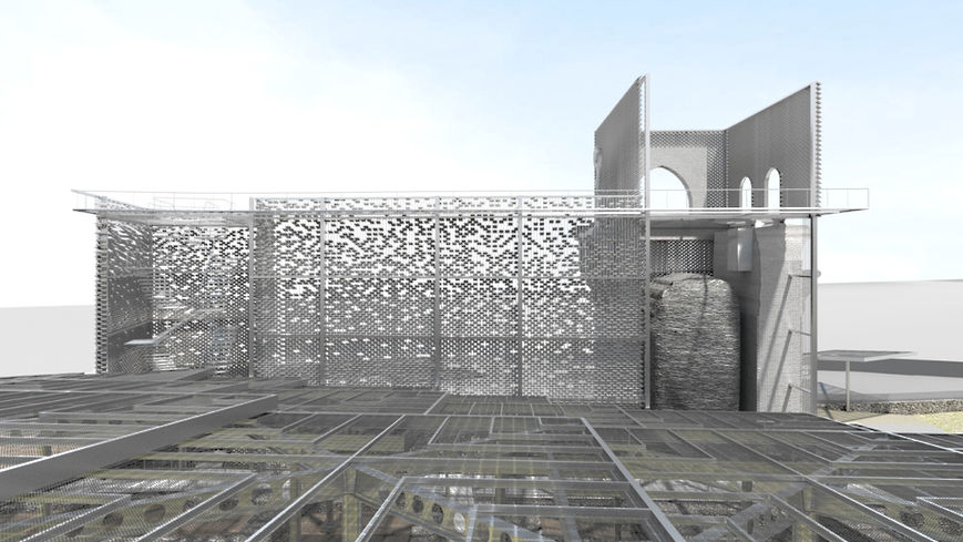
Designed for palace remnants, wall ruins, and potential architectural findings that may emerge from future archaeological excavations, a modular and adaptable unit has been planned. Each singular module, with an 8m8m square form and a 5% slope for rainwater drainage, is modular and can be shaped and connected according to possible scenarios. Seated on 6060 cm reinforced concrete legs, supported by steel carriers, each module rests on the soil surface within the archaeological area where no artifacts are found, and no interference with the foundation remnants has occurred. These modules, equipped with semi-permeable solar panels, provide shade, generate energy, and include lighting units needed for the archaeological site. Walkways and observation points planned for viewing archaeological remnants are also suspended from these modules. As part of the planned future scenario in the area, these individual modules will be used in future excavation areas and will organically expand.
Revitalization Technique
Soil bricks obtained from archaeological excavations in the area have been used to abstract the structural forms of archaeological remnants. Two methods have been proposed for structures with known or estimated forms that have reached remnants to the present day. In both methods, bricks are suspended from steel cables. For historically known remnants with clear massing information, the proposed arrangement is continuous and voided up to the top elevation. For remnants with unclear massing information, the increasing brick spacing towards the top suggests that the top elevation information has not reached the present day. Bricks tilt outward like louvers to prevent rainwater from entering while allowing remnants to be visible through the created gaps. Ten architectural elements, such as muqarnas, found in the excavation area, are anticipated to be exhibited by hanging in their known locations using the same steel suspension method
1/200 Site Plans, Sections ve Scenarios


Information Panels
Interactive information panels have been placed at key points in the excavation areas, providing information about the area's history and the project in a way that enhances the route experience. The 12 panels designated in Stage I ensure the continuity of the route. Placed in accordance with the 4-stage route, the panels provide general information about the hill at the entrance elevation of Stage 1. In Stage 2, as visitors follow the excavation area, the panels contain information about palace remnants. Stage 3 depicts the Kılıçarslan Mansion, while Stage 4 examines palace remnants and frescoes.

I-I' Section


II-II' Section
III-III' Section
Pedestrian Circulation Diagram
I. Stage Excavation Area: The first stage excavation area comprises the revitalization of the Kılıçarslan Mansion, the palace wall, and the reconstruction of the II. Mansion, covered by protective coverings. As part of the preservation of tangible cultural heritage, the Entrance Gate of the Wall Protection, which covers the palace remnants, is designed as the main entrance to the area. Upon entering the area, visitors become part of Stage 1 of the Archaeological Area Route. In Stage 1, remnants of the protective wall at ground level, recycled walls, and mansion structures are observed. Stage 1 of the route directs the visitor to Stage 2 with stairs following the wall trace. Stage 2 immerses the visitor in the experience by including the base of the II. Kilisarslan Mansion and the wall between the two mansions in the route. Stairs, expressing the mud filling of the 2nd Mansion, lead the visitor to Stage 3. In Stage 3, the visitor experiences the viewing function of the mansions while observing the Archaeological Area and the city. Using the exit stairs, the visitor proceeds to the next stage. Stage 4 of the route guides the visitor to the exit while also showcasing important remnants such as the palace remnants and frescoes. Each stage is designed as a continuous route offering different exhibition and information experiences. The exit from the area is at +6.5 elevation, directing the visitor to Alaeddin Mosque and the square.
Dual Staircase System
In order to have a single route for the Archaeological Area Route and to provide the visitor with a clear sequence of spaces to experience, a dual staircase system has been created with vertical circulation as both entrance and exit. The staircase for the transition from Stage 2 to Stage 3 is different from the one for the transition from Stage 3 to Stage 4. This design ensures a clear route for the itinerary. However, for a visitor who does not want to ascend to the viewing terrace, a direct transition from Stage 2 to Stage 4 is provided. This circulation difference is conveyed through the color of the staircase flooring and directional signs.

Render Görüntüleri

Minyatür

Sunum Paftaları


